|
|
|
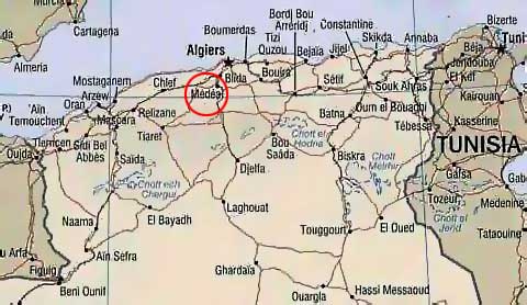
Médéa is a city in north-central Algeria with 130,000 inhabitants (2005 estimate), on the foot of Nador Mountain at an elevation of 920 metres. It is the capital of Lemdiyya province with 900,000 inhabitants (2005 estimate) and an area of 8,866 km˛. Médéa's economy is largely connected with local agriculture, which specializes in the production of wine and high-grade cereals. Medea has also some industry, producing pumps and irrigation equipment and different handicrafts. Médéa is connected with other urban centres with rail and road. Blida is 40 km north and Bouira 130 km east. The city is dominated by its French quarters with the rectangular city plan, public gardens and red-tiled buildings.
Médéa consists of 64 municipalities:
Ain Boucif, Ain Ou Ksir, Aissaouia, Aziz, Baata, Benchicao,
Beni Slimane, Berrouaghia, Bir Ben Laabed, Boghar, Bou Aiche, Bouaichoune, Bouchrahil, Boughezoui, Bouskene, Chahbounia Chelalet El Adhaoura,
Cheniguel, Damiat, Derrag, Deux Bassins, Djouab, Draa Essamar, El Azizia, El Guelbelkebir, El Hamdania, El Omaria, El Ouinet, Hannacha,
Kef Lakhdar, Khams Djouamaa, Ksar Boukhari, Maghraoua, Médéa, Medjebar, Meftaha, Mezerana, Mihoub, Ouamri, Oued Harbil, Ouled, Ouled Antar,
Ouled Brahim, Ouled Deide, Ouled Hellal, Ouled Maaref, Oum El Djalil, Ouzera, Rebaia Bouachra, Saneg, Sedraia, Seghouane, Si Mahdjoub, Sidi Damed,
Sidi Errabia, Sidi Naamane, Sidi Zahar, Sidi Ziane, Souagui, Tablat, Tafraout, Tamesguida, Tlatet Eddouair, Zoubiria.
The code for this Wilaya is: 26.